
Main Menu
Bandera County Data
Bandera County Communities & Places
Genealogy & History Links by USGHN
Important Bandera County Addresses
Sponsors
Bandera County Neighbors
Bexar County, Texas
Kendall County, Texas
Kerr County, Texas
Medina County, Texas
Real County, Texas
Uvalde County, Texas
Other Websites
Bandera County, Texas Communities & Places
| |||
Please submit your Bandera County, Texas communities and places for researchers to share. Send your information to the Bandera County, Texas Genealogy & History Network at: txghn@outlook.com
|
NAME |
LOCATION |
| A Bar A Ranch | 29.793555, -99.254486 |
| Anchor T Ranch | 29.847719, -99.286987 |
| Anderson Hollow | 29.769255, -99.424596 |
| Bandara County Park | 29.565229, -98.955308 |
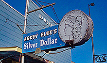
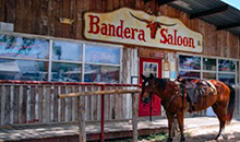
| Bandera | 29.726613, -99.073646 |
| Bandera City Municipal Building | 29.7262, -99.073386 |
| Bandera County Library | 515 Main Street, Bandera |
| Bandera Falls | 29.67717, -98.963365 |
| Bandera Pass | 29.862997, -99.107538 |
| Barnes Gap | 29.631616, -99.231151 |
| Beacon Point | 29.56634, -98.948919 |
| Bear Springs Blossom Nature Preserve | 29.77071, -98.931284 |
| Bee Bluff | 29.731891, -99.277541 |
| Bishop Hollow | 29.689346, -99.261007 |
| Blackjack Hollow | 29.655669, -99.595893 |
| Blunt Hollow | 29.746052, -99.413649 |
| Board Tree Hollow | 29.809825, -99.412949 |
| Brushy Hollow | 29.674387, -99.363647 |
| Buck Hollow | 29.665724, -99.423856 |
| Button Willow Hollow | 29.704071, -99.529325 |
| Camp Sionito | 29.755501, -99.174205 |
| Cap Mountain | 29.737723, -98.891974 |
| Castle Rock | 29.881051, -99.274764 |
| Cedar Hill Divide | 29.683558, -98.845306 |
| Cedar Hollow | 29.687164, -99.248088 |
| Cedar Hollow | 29.692123, -99.52247 |
| Chalk Hill | 29.747723, -99.469492 |
| Chalk Mountain | 29.692725, -99.24504 |
| Chimney Hollow | 29.810498, -99.421157 |
| Circle R Sky Ranch | 29.819943, -99.264486 |
| Clark Hollow | 29.679709, -99.114223 |
| Cloud Hollow | 29.777445, -98.988367 |
| Cold Hollow | 29.857996, -99.463103 |
| Copperhead Hollow | 29.809943, -99.412824 |
| Cottonwood Hollow | 29.717024, -99.523434 |
| Cousins Point | 29.570229, -98.943641 |
| Covy Hollow | 29.861329, -99.463936 |
| Cripple Creek Ranch | 29.806332, -99.320043 |
| Crow Canyon | 29.883829, -99.149206 |
| Deadwood Hollow | 29.702899, -99.270721 |
| Dewberry Hollow | 29.780217, -99.363925 |
| Duffys Mountain | 29.833554, -99.079203 |
| Eagle Bluff | 29.736613, -99.26393 |
| Echo Point | 29.557451, -98.967531 |
| Edwards Mountain | 29.745501, -98.934476 |
| El Paraiso Ranch | 29.740501, -99.234762 |
| Elam Canyon | 29.727163, -99.243366 |
| English Crossing | 29.681614, -98.975865 |
| English Hollow | 29.766612, -99.12587 |
| Fiddler Hollow | 29.768405, -99.592962 |
| Fivemile Hill | 29.688281, -98.998921 |
| Foster Hollow | 29.734239, -99.535131 |
| Frontier Times Museum | 29.730224, -99.07198 |
| Gate Hollow | 29.652721, -99.06836 |
| Goat Hill | 29.583284, -98.961975 |
| Gunsight Mountain | 29.680503, -99.311987 |
| Hay Hollow | 29.671468, -99.426259 |
| Highland Waters | 29.751612, -99.135871 |
| Hill Country State Natural Area | 29.633004, -99.191983 |
| Honey Creek Ranch | 29.864107, -99.423102 |
| Horse Valley Ranch | 29.855774, -99.368378 |
| Indian Hollow | 29.682533, -99.597088 |
| Indian Hollow | 29.774389, -99.388378 |
| Iron Top Mountain | 29.708002, -99.303375 |
| Jim Jernigan Hollow | 29.750908, -99.571655 |
| Jureczki House | 29.720502, -99.075591 |
| Lake Hills | 29.584395, -98.948919 |
| Lake Medina Highlands | 29.568007, -98.957253 |
| Lake Medina Shores | 29.638358, -98.986885 |
| Lakehills | 29.604672, -98.943086 |
| Lakehills Area Library | 7200 FM-1283, Lakehills |
| Langford Mountain | 29.81661, -99.008923 |
| Liebold Mountain | 29.622727, -98.956975 |
| Lin Hollow | 29.863274, -99.433936 |
| Long Hollow | 29.699348, -99.545939 |
| Lost Maples State Natural Area | 29.819722, -99.583056 |
| Lovers Leap | 29.736057, -99.223651 |
| Marshy Hollow | 29.717496, -99.559371 |
| Massey Hollow | 29.759395, -99.579656 |
| Medina | 29.79661, -99.24643 |
| Medina Childrens Home | 29.883551, -99.275876 |
| Monroe Hollow | 29.681331, -99.293645 |
| Montague Hollow | 29.752723, -99.126148 |
| Mount Medina | 29.828554, -99.126149 |
| Mule Hollow | 29.650019, -99.086057 |
| Negro Hollow | 29.762167, -99.438657 |
| Padgett Hollow | 29.699386, -99.274478 |
| Panther Hill | 29.67967, -99.55005 |
| Panther Hollow | 29.755779, -99.131704 |
| Pecan Ranch | 29.852163, -99.307265 |
| Pipe Creek | 29.723557, -98.935864 |
| Polly Peak | 29.775778, -99.011423 |
| Porter Ranch | 29.894106, -99.329766 |
| Potato Flats | 29.641893, -99.069757 |
| Prison Canyon | 29.889385, -99.128094 |
| Purple Sage Ranch | 29.75189, -99.035312 |
| Ranch Hollow | 29.883829, -99.205874 |
| Raven Roost Hollow | 29.760223, -99.446713 |
| Reed Ranch | 29.891884, -99.381712 |
| Rock Chimney Ranch | 29.802721, -99.408935 |
| Rocky River Ranch | 29.784666, -99.31921 |
| Round Mountain | 29.738001, -99.356988 |
| Rugh Hill | 29.712169, -99.079202 |
| Sabinal Canyon | 29.768, -99.564218 |
| Saddleback Mountain | 29.642449, -99.290041 |
| Seco Mountain | 29.679114, -99.384489 |
| Seco Pass | 29.682447, -99.388655 |
| Seep Springs Hollow | 29.712442, -99.554764 |
| Sentry Mountain | 29.666892, -99.42949 |
| Short Hollow | 29.745688, -99.536566 |
| Slaughter Hollow | 29.855496, -99.446436 |
| Smoothing Iron Mountain | 29.665226, -98.920864 |
| Soto Mountain | 29.698558, -99.28393 |
| Stove Hollow | 29.679715, -99.114215 |
| Sugarloaf Hill | 29.848831, -99.093926 |
| Sugarloaf Mountain | 29.676059, -99.256152 |
| Sunset Mountain | 29.840498, -99.070592 |
| Sutherland Hollow | 29.748001, -99.416157 |
| Sycamore Hollow | 29.688804, -99.594814 |
| Tarpley | 29.65717, -99.27643 |
| Tarpley Pass | 29.681059, -99.19865 |
| Taylor Mountain | 29.726057, -99.527271 |
| The Bluff | 29.878273, -99.288098 |
| Three Mountains | 29.734945, -98.871418 |
| Town Mountain | 29.703003, -99.092258 |
| Townsend Camp Hollow | 29.733979, -99.358771 |
| Tuff | 29.769111, -99.403656 |
| Vanderpool | 29.745223, -99.55505 |
| Weed Bluff | 29.747446, -99.422268 |
| Well Hollow | 29.887085, -99.531856 |
| Wernette Mountain | 29.661893, -99.507826 |
| Wet Hollow | 29.783427, -99.32445 |
| White Bluff | 29.880218, -99.343933 |