
Main Menu
Cass County Data
Cass County Communities & Places
Genealogy & History Links by USGHN
Important Cass County Addresses
Sponsors
Cass County Neighbors
Bowie County, Texas
Caddo Parish, Louisiana Genealogy & History Network
Marion County, Texas
Miller County, Arkansas
Morris County, Texas
Other Websites
Cass County, Texas Communities & Places
| |||
Please submit your Cass County, Texas communities and places for researchers to share. Send your information to the Cass County, Texas Genealogy & History Network at: txghn@outlook.com
|

NAME |
LOCATION |
| Almira | 33.100128, -94.445475 |
| Antioch | 33.185406, -94.255747 |
| Armstrong Landing | 33.227349, -94.278803 |
| Atlanta | 33.113742, -94.164354 |
| Atlanta City Hall | 33.118856, -94.165457 |
| Atlanta City Park | 33.129575, -94.163243 |
| Atlanta Public Library | 29.559393, -94.166014 |
| Atlanta State Park | 33.232072, -94.249358 |
| Avinger | 32.899855, -94.556312 |
| Bear Creek | 32.929856, -94.450474 |
| Bells Island | 33.282904, -94.196302 |
| Bethlehem | 33.149015, -94.512422 |
| Bethsaida | 33.035688, -94.187964 |
| Bivins | 33.019577, -94.199076 |
| Bloomburg | 33.137909, -94.057406 |
| Bloomburg City Hall | 33.137979, -94.057918 |
| Bryans Mill | 33.235124, -94.497978 |
| Carterville | 33.069295, -94.472142 |
| Cass | 33.19513, -94.06324 |
| Cass County Courthouse | Unknown |
| Caves Spring | 32.966799, -94.399361 |
| Cornett | 33.12957, -94.574646 |
| Courtland (historical) | Unknown |
| Crossroads | Unknown |
| Cusseta | 33.162348, -94.45742 |
| Cusseta Mountains | 33.17457, -94.465754 |
| Dalton | 33.204845, -94.59687 |
| Domino | 33.265128, -94.115187 |
| Donaldson Mountain | 32.98152, -94.502976 |
| Doss | Unknown |
| Douglassville | 33.192071, -94.353528 |
| Douglasville Lookout | 33.185128, -94.276303 |
| Evans | 32.941246, -94.252688 |
| Fairview | 32.946522, -94.378249 |
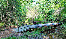
| Flat Creek Bridge | 32.999298, -94.46603 |
| Forest Home (historical) | Unknown |
| Gum Springs | 33.149572, -94.36075 |
| Hickory Hill | 33.22235, -94.211023 |
| Huffins | 32.9993, -94.13574 |
| Hughes Springs | 32.998462, -94.630759 |
| Hughes Springs City Hall | 32.997919, -94.625613 |
| Jackson Park | 33.221238, -94.303526 |
| Kildare | 32.943191, -94.248244 |
| Kildare Junction | 32.90847, -94.18852 |
| Knights Bluff | 33.237905, -94.252969 |
| Knights Bluff Landing | 33.239016, -94.255469 |
| Lacey Bridge | 32.893746, -94.441585 |
| Lanark | 33.182074, -94.149354 |
| Lanier | 32.935412, -94.373804 |
| Liberty | 32.884579, -94.448252 |
| Linden | 33.012354, -94.365471 |
| Linden City Hall | 33.011392, -94.365621 |
| Lions Park | 33.013743, -94.362971 |
| Love | 32.970686, -94.608814 |
| Marietta | 33.173458, -94.542423 |
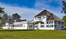
| Mathews-Powell House | 33.149852, -94.147409 |
| McCartney Bridge | 33.304571, -94.151578 |
| McLeod | 32.94458, -94.080183 |
| McNobie Park | 33.123464, -94.176299 |
| Midway | 33.089293, -94.582146 |
| Midway | 33.164295, -94.294914 |
| New Colony | 33.047909, -94.29908 |
| New Liberty | 33.171795, -94.257135 |
| Nickleberry | 33.146793, -94.5202 |
| Oak Grove | 33.062632, -94.205188 |
| O'Farrell | 33.124573, -94.320748 |
| Overcup Landing | 33.237903, -94.366307 |
| Panhandle | 33.221237, -94.346028 |
| Patman | 32.955131, -94.572423 |
| Patman Switch | Unknown |
| Pine Bluff | 33.248459, -94.310471 |
| Pleasant Hill | 33.053186, -94.397139 |
| Poorboy Landing | 33.225127, -94.302138 |
| Pruett | 32.891802, -94.357971 |
| Pruitt Lake | 32.951799, -94.502699 |
| Queen City | 33.148741, -94.150187 |
| Queen City City Hall | 33.148329, -94.153605 |
| Rambo | 32.917915, -94.091295 |
| Red Hill | 33.123184, -94.371306 |
| Roach | 33.069575, -94.271857 |
| Rocky Point Park | 33.299293, -94.165468 |
| Sardis | 33.00513, -94.541033 |
| Sheffield | 32.936802, -94.253799 |
| Smyrna | 33.078188, -94.084351 |
| Springdale | 33.233184, -94.133243 |
| Thomas Lake Park | 33.266512, -94.470199 |
| Three States | 33.019301, -94.042682 |
| Walton | 32.93847, -94.046849 |
| Warren Springs | 33.062352, -94.376583 |
| Wilson Bend | 33.296516, -94.120188 |