
Main Menu
Caldwell County Data
Caldwell County Communities & Places
Genealogy & History Links by USGHN
Important Caldwell County Addresses
Sponsors
Caldwell County Neighbors
Bastrop County, Texas Genealogy & History Network
Fayette County, Texas
Gonzales County, Texas Genealogy & History Network
Guadalupe County, Texas
Hays County, Texas
Travis County, Texas
Other Websites
Caldwell County, Texas Communities & Places
| |||
Please submit your Caldwell County, Texas communities and places for researchers to share. Send your information to the Caldwell County, Texas Genealogy & History Network at: txghn@outlook.com
|
NAME |
LOCATION |
| Albade (historical) | Unknown |
| American Indian Horse Museum | 29.895278, -97.670278 |
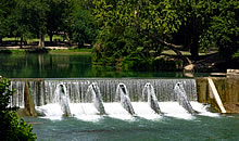
| Barth Lake Dam | 29.908611, -97.681944 |
| Bear Gulch | 29.752222, -97.455000 |
| Brooks Place Airport (historical) | 29.912778, -97.633611 |
| Brownsboro | 29.783889, -97.609167 |
| Burdette Wells (historical) | Unknown |
| Caldwell County Courthouse Historic District | 29.885833, -97.669167 |
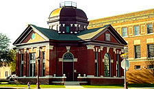
| Caldwell County Museum | 29.885000, -97.666667 |
| Clark Lake Dam | 30.006944, -97.686944 |
| Comanche Flats | 29.843056, -97.608889 |
| Cooper Lake Dam | 29.866944, -97.796944 |
| Dale | 29.927500, -97.564444 |
| Dale Post Office | 29.926111, -97.565000 |
| Delhi | 29.827500, -97.395556 |
| Devil Hollow | 29.840000, -97.426389 |
| Duddleston Lake Dam | 29.825278, -97.363611 |
| Elm Grove | 29.890833, -97.487500 |
| Fentress | 29.756111, -97.776389 |
| Fentress Post Office | 29.758056, -97.776667 |
| Grouskay-Fisher Lake Dam | 29.845278, -97.793611 |
| Iron Mountains | 29.721111, -97.513333 |
| Iron Peak | 29.665556, -97.548889 |
| Joliet | 29.769444, -97.679167 |
| Koeglar Hill | 29.902222, -97.817222 |
| Langford Lake Dam | 29.771944, -97.806944 |
| Lockhart | 29.878611, -97.683056 |
| Lockhart | 29.885000, -97.670000 |
| Lockhart City Park | 29.891389, -97.662500 |
| Lockhart Post Office | 29.883611, -97.674167 |
| Lockhart State Park | 29.851389, -97.698611 |
| Long Hollow | 30.046111, -97.625278 |
| Longer Park | 29.678056, -97.648333 |
| Luling | 29.681667, -97.646667 |
| Luling | 29.680556, -97.647500 |
| Luling Post Office | 29.680000, -97.649167 |
| Lytton Springs | 30.004722, -97.612500 |
| M. A. Withers House | 29.871111, -97.727222 |
| Macon Lake Dam | 29.738611, -97.518611 |
| Martindale | 29.845000, -97.840556 |
| Martindale | 29.845556, -97.840833 |
| Martindale Post Office | 29.844444, -97.842778 |
| Maxwell | 29.881111, -97.793333 |
| Maxwell Post Office | 29.878611, -97.795556 |
| McMahan | 29.852778, -97.519444 |
| McNeil | 29.708333, -97.584444 |
| Mendoza | 30.005000, -97.686111 |
| Mineral Springs (historical) | 29.775278, -97.679722 |
| Mustang Ridge | 30.057778, -97.650833 |
| Niederwald | 30.009444, -97.728056 |
| Northside Park | 29.690278, -97.649722 |
| Pettytown | 29.907500, -97.459444 |
| Pool Hollow | 29.951667, -97.580556 |
| Prairie Lea | 29.732500, -97.753611 |
| Prairie Lea Post Office | 29.731389, -97.753333 |
| Reedville | 29.879722, -97.846389 |
| Round Mountain | 29.751944, -97.505556 |
| Saint Johns Colony | 29.971111, -97.558333 |
| San Marcos Army Air Field (historical) | 29.890000, -97.865556 |
| Seawillow | 29.823333, -97.605556 |
| Segler Lake Dam | 29.925278, -97.625278 |
| Soda Springs | 29.718889, -97.599167 |
| Southside Park | 29.665556, -97.648889 |
| Stairtown | 29.718333, -97.727778 |
| Taylorsville | 29.896111, -97.498056 |
| Tilmon | 29.797778, -97.553333 |
| Uhland | 29.957778, -97.786111 |
| Watts | 29.756944, -97.567222 |
| Withers Hollow | 29.977500, -97.714722 |