Main Menu
Concho County Data
Concho County Communities & Places
Genealogy & History Links by USGHN
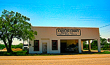
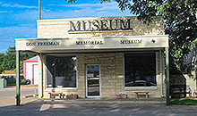
Important Concho County Addresses
Sponsors
Concho County Neighbors
Coleman County, Texas
McCulloch County, Texas
Menard County, Texas
Runnels County, Texas
Schleicher County, Texas
Tom Green County, Texas
Other Websites
Welcome to Concho County Texas Genealogy & History Network!
Welcome to the Concho County, Texas Genealogy & History Network. Our purpose is to provide visitors with free resources for genealogical and historical research. To share your genealogy or history information, send an email to txghn@outlook.com and we will happily include it here. For other Texas Counties, visit the Texas Genealogy & History Network state website and go to the appropriate county. Thanks for visiting and good luck with your research! |
|
About Concho County, Texas...
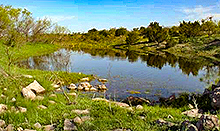
Concho County is located in Central Texas. The county derives its name from the Concho (or "Shell") River, which in turn was named for the large number of mussels found there. Paint Rock, the county seat, is situated in the north central part of the county approximately thirty miles east of San Angelo and 150 miles northwest of Austin.
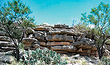
The two sites of Indian activity in Concho County that have drawn the most attention lie along the bluffs of the Concho and Colorado rivers. About a mile west of Paint Rock, above the Concho, are found some of the most noted Indian pictographs in Texas. To the east of Paint Rock on the Colorado, the area of O. H. Ivie Reservoir has been the scene of the most intensive archeological investigation in the county. Evidence here indicates occupation as early as 10,000 to 8,000 B.C.
The area was attractive for its plentiful food, water, and lithic resources, and for the protective high cliffs along the river. The diet of the groups who camped here may have consisted of such plant foods as yucca, prickly pear, mesquite beans, pecans, and grass seeds, as well as fish, mussels, prairie chickens, and wild turkeys. In 1981 this area marked the farthest point north that ring middens and burned-rock middens had been discovered.
Around 1500 Athabascan-speaking Indians associated with the prehorse Plains culture lived in this part of Texas. In the 1600s the Jumanos established themselves along the Concho and traded with the Spaniards. Seeking protection against the Lipan Apaches, in 1683 the Jumanos requested that the Spaniards establish a mission in their territory. After several months, however, attacks by the Apaches forced the Spaniards to withdraw.
 By 1771 the Jumanos had apparently been absorbed by the Lipans. A map of Texas in 1776 places the area of Concho County within the domain of the Lipans, which extended southward from the Colorado River. The territory above the Colorado belonged to the Comanches, and that east of the Colorado to the Tonkawas. By about 1840 the Comanches had overrun the area of Concho County and pushed as far south as the vicinity of modern Austin. The last significant conflict in the area between Indians and whites ended with the 1874 campaign which drove the remaining Indians out of the region and forced them onto reservations.
The area of present-day Concho County was included in the Fisher-Miller Land Grant of 1842. In 1847 John O. Meusebach, after concluding a peace treaty with the Comanches, sent surveyors into the tract on behalf of the society. The area surveyed included much of the land along the banks of the Concho River now in Concho County. Although the colonization contract stipulated that the lots surveyed should be as nearly square as possible, the survey marked off long lots along the Concho. This may have been done to increase access to a water supply, since rain in the region is sparse. The Concho country did not yet attract immigration, however, as it lay beyond the farming frontier where Indian attacks were frequent.
The legislature formed Concho County out of Bexar County in 1858, but it was not organized until 1879. In the meantime, in the early to middle 1860s, cattlemen began to move into the open range in Concho and adjacent counties. John S. Chisum, the first large-scale cattleman in the county, established a string of cow camps on the Concho River in the northeastern part of the county in 1862 or 1863. He moved his headquarters to New Mexico in 1873, though he still had a camp on the Concho near the site of present-day Paint Rock in the fall of that year.
 As the Texas farming frontier advanced, cattle drives shifted from the more easterly Chisholm and Shawnee trails to the Western Trail. The Western Trail began in South Texas and pushed northward through the center of Concho County, crossing the Colorado River at the Concho-Coleman county line. Near the site of present-day Eden the Goodnight-Loving Trail branched off from the Western Trail and led toward New Mexico. By the mid-1880s, however, most of the grazing land in Concho County had been enclosed.
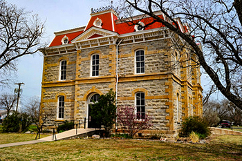
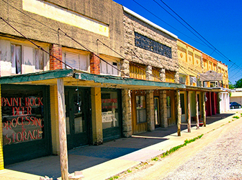
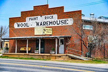
Concho County was organized in 1879. The location chosen for the county seat was at a ford on the Concho about a mile below the mouth of Kickapoo Creek. The county seat was named Paint Rock, after the nearby pictographs. The town developed steadily. By 1884 it had an estimated population of 100 and had become a shipping center for pecans, wool, hides, and mutton. In 1886 a permanent courthouse was constructed.
At the time of the first census, most settlers had come from Arkansas, Tennessee, Mississippi, Alabama, and Kentucky. A map of nineteenth-century cultural distributions in the county shows the eastern half dominated by the "Appalachian hill folk" culture, a way of life imported chiefly from the Appalachians and Ozarks and oriented to a subsistence economy. The western half of the county had a blend of the Appalachian culture and that of the middle-class upper South, which embraced grain and cotton farming and was oriented to a market economy.
In the mid-twentieth century, concentrations of ethnic groups in the county included pockets of Germans in the northwest corner and a cluster of Swedes on the Concho-McCulloch county line. In 1970 over 100 Czechs resided in the vicinity of Eola, in the far west central part of the county. A 1971 map of religious affiliation showed, in the extreme northwest corner, a Catholic simple majority with substantial Lutheran and Reformed representation. In the extreme southeast, Baptists were a simple majority and Methodists had a significant presence. Elsewhere in the county Baptists were an absolute majority and Methodists a minority.
 The local economy, based originally on cattle, soon embraced sheep ranching and farming. In 1988 Concho County was the leading sheep-producing county in Texas. Sheep were first introduced into the county in the 1870s and by 1890. After a coyote-eradication campaign between 1917 and 1922 the number of sheep soared. Most shepherds employed in the care of these flocks were Mexican-American pastores. Angora goats also became an important resource.
The number of farms in Concho County increased dramatically between 1900 and 1910, the decade of swiftest population growth. The total of 865 farms in 1910, compared to 119 in 1900, marks the second highest recorded level, next to the top figure of 1,137 reached in 1930.
The dramatic increase in cotton production in Concho County reflected the fiber's growing importance both at home and abroad. But by 1928 prices began to signal a glut in the market. With the onset of the international depression, revenues from cotton plummeted. Beginning in 1933 the federal government undertook a series of measures designed to limit the amount of cotton grown. Other factors discouraging production included an increased import allowance on foreign-grown cotton, the introduction of synthetics, and a shortage of labor during World War II. In 1940 cotton still claimed the most acres in Concho County.
In the early decades, education in Concho County was largely a matter of one-teacher country schools. By 1940 the county had four independent school districts, in the incorporated communities of Paint Rock, Eden, Eola, and Millersview, and ten common-school districts. By 1955 the total number of districts had been reduced to four and by 1989 to two, Paint Rock and Eden.
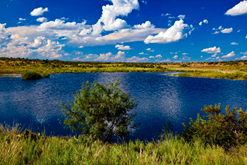
Concho County attractions include boating, hunting, fishing, the Paint Rock pictographs, and the Concho County Fair, which is held annually in August and September.
 The county has a total area of 994 square miles, of which 984 square miles is land and 10 square miles (1.0%) is water. The population recorded in the 1880 Federal Census was 800. The population peaked in 1930 at 7,645. The 2010 census recorded 4,087 residents there.
Neighboring counties are Runnels County (north), Coleman County (northeast), McCulloch County (east), Menard County (south), Schleicher County (southwest), and Tom Green County (west). The county seat is Paint Rock. Other communities in the county include Eden, Eola, Lowake, and Millersview.
Concho County, Texas Records
Birth Records - The Texas Department of State Health Services has records from 1903 to present. Records for the last 75 years considered private and will only be provided to certain individuals. To obtain current information on who may obtain a record, how to submit a request and an official request form, see the Texas Department of State Health Services website or write to Texas Vital Records, Department of State Health Services, P.O. Box 12040, Austin, TX 78711-2040.
For older birth records you will have to write to the County Clerk of the applicable county. The existence of birth records prior to 1903 will vary widely from county to county. Local historical societies and genealogy collections in local libraries may be able to provide some information.
Death Records - The Texas Department of State Health Services has records from 1903 to present. Records for the last 25 years considered private and will only be provided to certain individuals. To obtain current information on who may obtain a record, how to submit a request and an official request form, see the Texas Department of State Health Services website or write to Texas Vital Records, Department of State Health Services, P.O. Box 12040, Austin, TX 78711-2040.
Marriage Records - The Texas Department of State Health Services can provide a verification letter of marriage for Texas marriages from 1966 to present. This is NOT a marriage license. To obtain a certified copy of a marriage license you must contact the County or District Clerk in the county or district where the marriage took place.
Local historical societies and genealogy collections in local libraries may be able to provide some information.
Divorce Records - The Texas Department of State Health Services can provide a verification letter of divorce for Texas divorces from 1968 to present. This is NOT a copy of the divorce decree. To obtain a certified copy of a copy of the divorce decree you must contact the County or District Clerk in the county or district where the divorce took place.
Local historical societies and genealogy collections in local libraries may be able to provide some information.