
Main Menu
Hardeman County Data
Hardeman County Communities & Places
Genealogy & History Links by USGHN
Important Hardeman County Addresses
Sponsors
Hardeman County Neighbors
Childress County, Texas
Cottle County, Texas
Foard County, Texas Genealogy & History Network
Harmon County, Oklahoma
Jackson County, Oklahoma
Other Websites
Welcome to Hardeman County Texas Genealogy & History Network!
Welcome to the Hardeman County, Texas Genealogy & History Network. Our purpose is to provide visitors with free resources for genealogical and historical research. To share your genealogy or history information, send an email to txghn@outlook.com and we will happily include it here. For other Texas Counties, visit the Texas Genealogy & History Network state website and go to the appropriate county. Thanks for visiting and good luck with your research! |
|
About Hardeman County, Texas...
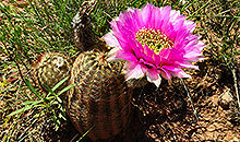
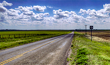
Hardeman County is west of Wichita Falls in the Rolling Plains region of northwest Texas. Quanah is the county seat and the largest town. The northern two-thirds is drained by the Red River, which forms the northern boundary, and the southern part is drained by the Pease River. Between 30 and 40 percent of the land in the county is considered prime farmland. The vegetation is typical of the Rolling Prairies, with tall to medium-tall grasses and mesquite or shinnery oak trees.
Lipan Apaches dominated the region in the sixteenth and seventeenth centuries. Later the semisedentary Wichita Indians settled along the Red River. After 1700 the Comanches and Kiowas also migrated from the north to hunt buffalo and other game. The county was formed in 1858 from Fannin County and named for early Matagorda legislators Bailey and Thomas Jones Hardeman. Because of its isolation and the continued threat of Indian attack, however, the area remained unsettled during the Civil War and Reconstruction.
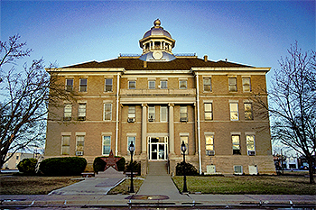
After the Civil War a few buffalo hunters and ranchers moved to the region, but it was still only very sparsely settled when the county was organized in 1884. In the 1870s and 1880s rustling was among the principal industries, as thieves headed for Indian Territory crossed Hardeman County to reach the Red River. From 1881 to 1884 Wilbarger County administered Hardeman County's legal affairs, though its handful of settlers had few administrative needs. Margaret, first called Argurita, was the original county 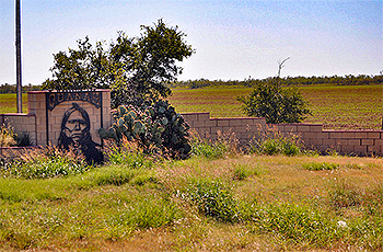 seat. An election held in 1890 made Quanah the county seat. Foard County was formed from Hardeman, Cottle, King, and Knox counties, a division that left Margaret in Foard County.
From 1875 to 1890 Hardeman County was principally a ranching area. In early years, before the construction of the railroad, cattlemen of the R2 Ranch, which covered thirty-five square miles of Hardeman County, and other ranchers drove their herds to Dodge City, Kansas. Cowboys picked up the Western (or Dodge City) Trail at Doan's Crossing of the Red River, near Vernon. After the completion of the railroad in 1887, Quanah emerged as an important shipping point for the surrounding area. By 1890 there were some 25,000 cattle on the county's ranches.
The arrival of the railroad brought other dramatic changes in the area. Lured by the promise of abundant, inexpensive land, large numbers of new settlers began pouring in during the late 1880s. Between 1880 and 1890 the population of Hardeman county grew nearly a hundredfold. Many of the settlers were farmers, who began to till and fence the land. In the eastern part of the county they were planting wheat by 1889 and producing oats and wheat in substantial amounts by 1890.
Higher than average rainfall, good weather, and soaring commodities prices induced some farmers to plow immense stretches of raw prairie for planting. But in 1892 prices fell dramatically, and the following year the entire crop failed. For much of the rest of the decade, Hardeman County farmers struggled. The economy began to recover at the turn of the century, in part because of the introduction of large-scale 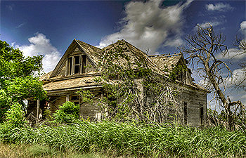 cotton culture. In 1890 only 314 acres was planted in cotton; by 1910 the total was nearly 35,000. In 1910, Hardeman County farmers ginned 8,139 bales; in 1914, at the peak of early cotton boom, more than 30,000 bales were ginned.
After 1900, because of the rapidly growing population, land prices showed a marked increase, and many new farmers found it impossible to afford land. The number of tenants and sharecroppers grew rapidly, particularly in the 1920s, and by 1930 nearly two out of every three farmers were working someone else's land. In contrast to many other areas of the state the overwhelming majority of the tenants were white, but the practice nonetheless had serious results in the 1930s.
Although the amount of land planted in cotton continued to be quite high-as much as 144,994 acres in 1930-both yields and profits dropped significantly, especially after 1932. In 1930 Hardeman County farmers produced only 26,573 bales, half the peak figure of the late 1920s; and by 1936 the number of bales ginned had fallen to 4,301. As a result of poor crop yields and the reluctance of banks to extend credit to financially strapped farmers, many of those who made a living from the land, particularly tenants, found themselves in a precarious position. Numerous farmers were forced to give up their livelihood and seek work elsewhere. Between 1930 and 1940 the number of farms in the county fell by almost a third, and by 1940 only slightly more than half the number of tenants of a decade before were still on the land.
The economy began to recover during World War II, partly as a result of the discovery of oil in 1944, which helped many cash-poor farmers to settle long-standing debts. Cotton farming continued to decline after 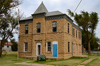 the war, and by the 1960s only six gins were in operation. Subsequently wheat was the leading crop. Hardeman County was near the top of wheat-producing counties in the state. Much of the western part of the county is ranching country, with cattle the leading revenue producer. Gypsum deposits were discovered in Hardeman County in 1890, and production of plaster began in 1903. Production of gypsum products became a leading industry in Quanah.
The first churches in the county were established shortly after its organization. In the mid-1980s the county had twenty-two churches, with an estimated combined membership of 5,000. The largest denominations were Baptist, Methodist, and Church of Christ.
The population of Hardeman County fell steadily after the eve of World War II, as residents gradually moved away to find jobs. In 1990 more than half of the population of Hardeman County lived in Quanah. The largest ancestry groups are English, Irish, German, and Hispanic.
Copper Breaks State Park and Lake Pauline provide recreation. Among the leading attractions are the Medicine Mounds, four cone-shaped hills rising 350 feet above the surrounding plain, that were once held by the Comanches to have magical powers.
The county has a total area of 697 square miles, of which 695 square miles is land and 2 square miles  (0.3%) is water. The population recorded in the 1880 Federal Census was 50. The population peaked in 1930 at 14,532. The 2010 census recorded 4,139 residents there.
Neighboring counties are Harmon County, Oklahoma (north), Jackson County, Oklahoma (northeast). Wilbarger County (east), Foard County (south), Cottle County (southwest), and Childress County (west). The county seat is Quannah. Other communities in the county include Chillicothe, Goodlet, Acme, and Medicine Mound.
Hardeman County, Texas Records
Birth Records - The Texas Department of State Health Services has records from 1903 to present. Records for the last 75 years considered private and will only be provided to certain individuals. To obtain current information on who may obtain a record, how to submit a request and an official request form, see the Texas Department of State Health Services website or write to Texas Vital Records, Department of State Health Services, P.O. Box 12040, Austin, TX 78711-2040.
For older birth records you will have to write to the County Clerk of the applicable county. The existence of birth records prior to 1903 will vary widely from county to county. Local historical societies and genealogy collections in local libraries may be able to provide some information.
Death Records - The Texas Department of State Health Services has records from 1903 to present. Records for the last 25 years considered private and will only be provided to certain individuals. To obtain current information on who may obtain a record, how to submit a request and an official request form, see the Texas Department of State Health Services website or write to Texas Vital Records, Department of State Health Services, P.O. Box 12040, Austin, TX 78711-2040.
Marriage Records - The Texas Department of State Health Services can provide a verification letter of marriage for Texas marriages from 1966 to present. This is NOT a marriage license. To obtain a certified copy of a marriage license you must contact the County or District Clerk in the county or district where the marriage took place.
Local historical societies and genealogy collections in local libraries may be able to provide some information.
Divorce Records - The Texas Department of State Health Services can provide a verification letter of divorce for Texas divorces from 1968 to present. This is NOT a copy of the divorce decree. To obtain a certified copy of a copy of the divorce decree you must contact the County or District Clerk in the county or district where the divorce took place.
Local historical societies and genealogy collections in local libraries may be able to provide some information.